The best-in-class long-range laser scanning system producing survey-grade point cloud data.
Built for precision and accuracy.
Designed and manufactured in North America.
0
m
Scanning Range
0
ft
Scanning Range
0
cm
Global Accuracy
0
million
Points Per Second
Draganfly’s Long Range LiDAR (DLR- LiDAR) system provides accurate distance measurements and improved resolution over conventional photogrammetry methods. The cutting-edge sensor technology can be mounted on UAV, airplanes, and helicopters for those professionals requiring precision imagery.
Ultimate LiDAR System
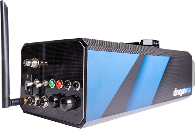
Draganfly Long Range LiDAR integrates the most advanced sensors from a world leader with 40 years of sensor experience, Teledyne (LiDAR sensor), and trusted industry expert, Applanix (IMU + GNSS).
Teledyne’s components are used in commercial and military aerospace design, while Applanix (a Trimble company) remain the industry standard in survey components worldwide.
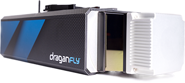
Best-in-class Laser Scanner
The Teledyne sensor produces survey-grade point clouds with a 360-degree laser scanner. Up to 750-meter/2460 feet range (50kHz). Class-leading point cloud fidelity with a low beam divergence allows for a safe scanning distance from the ground in even the most hazardous terrain.
Four laser returns capture more ground points and enable high-accuracy bare earth models under the thickest vegetation. Draganfly Long Range LiDAR produces 0.5cm point cloud precision with 2cm global accuracy resulting in high-resolution data at 2 million points per second.
Application Versatility
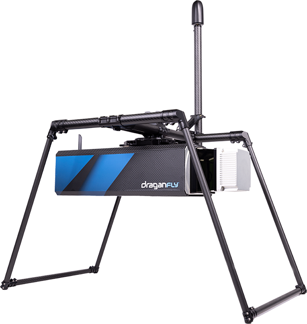
The Draganfly LiDAR provides versatility in mounting options. It can be mounted on UAVs, airplanes, helicopters or used as a mobile scanning solution when mounted on a vehicle or backpack providing accurate mapping data for all industries.
Complete Software Suite
The Draganfly LiDAR includes pre-processing software to process your Raw LiDAR, IMU, and GNSS data into a point cloud (LAS, LAZ). LiDAR360 post-processing software is available for further processing and analysis.
AERIAL MAPPING │ AGRICULTURE, ARCHAEOLOGY & FORESTRY │ CONSTRUCTION │ DISASTER RECOVERY MILITARY │ LAW ENFORCEMENT │ GEOGRAPHY │ SAFETY AND SURVEY INSPECTIONS │ SEARCH AND RESCUE SITE SURVEY │ SOLAR ENERGY │ RESOURCE MANAGEMENT │ UNDERGROUND MAPPING │ WIND TURBINE INSPECTION │ HYDRODYNAMIC MODELING │ DIGITAL ELEVATION MODELS │ MINING
AERIAL MAPPING AGRICULTURE, ARCHAEOLOGY & FORESTRY CONSTRUCTION DISASTER RECOVERY MILITARY LAW ENFORCEMENT GEOGRAPHY SAFETY AND SURVEY INSPECTIONS SEARCH AND RESCUE SITE SURVEY SOLAR ENERGY RESOURCE MANAGEMENT UNDERGROUND MAPPING WIND TURBINE INSPECTION HYDRODYNAMIC MODELING DIGITAL ELEVATION MODELS MINING
Request a Demo
Reach out to a Sales Specialist today to learn more about our Custom Solutions.
Contact our team to discuss our ready-to-ship, turnkey commercial drones and custom solutions.
Our LiDARexpert will hand-deliver the system to your organization to ensure a smooth transition into your new LiDARsystem and join your first onsite project.
Download the Long Range LiDAR Specifications Sheet
Tim Dunnigan is a thought leader and serial entrepreneur who served 22-years in the U.S. Army
as a Soldier, NCO, and Commissioned Officer where he filled a myriad of dynamic leadership
roles and global assignments, including three combat tours of duty. His 20-years of
entrepreneurial success is guided by transformational ideas and ventures in technology,
innovation, and education. Tim is the CEO & Founder at CaptureTec, LLC – a Center for
Verification and Evaluation Certified, Service-Disabled Veteran-Owned Small Business (CVE
SDVOSB) focused on leadership consultation, systems integration, and solutions that provide
data capture for infrastructure assets using aerial, static, and mobile scanning technologies. As
the COO and Co-founder at Talon Aerolytics, Tim architected the nation’s largest aerial drone
services provider from inception to all 50 states serving clients including AT&T, Nokia, T-Mobile,
Ericsson, and Verizon. As the CEO & Founder at Strategic Integration (CVE SDVOSB), Tim
developed the CTED (Create, Test, Educate, Deploy) turnkey business model for defense
consulting and technology integration, while serving America’s interests abroad through multiple
U.S. DoD classified hardware and software contracts in the U.S. and overseas. Additionally, Tim
is the Founder of Innovalearn, where he created education content for clients including Aflac,
Synovus, Subway, and Cox Communications; the Founder of iK9 (CVE SDVOSB), where he
co-authored the Veterans Administration (VA) training protocols for service dogs for Veterans
with PTSD; and the Co-founder of GameLink Lounge, where he architected innovative
entertainment concepts for Service Members and their families on Military installations across
the U.S.
Tim is also the Founder of the I’m a Hero Too Foundation [501(c)(3)] and a children’s book
author. He holds a Bachelor’s Degree in Human Development, a Master’s Degree in
Organizational Leadership and Management, and has completed 2-years of PhD studies in
Adult Education at Auburn University. Tim’s been awarded 6 patents and currently has two
patents pending on an aerial drone delivery system he developed to fill capability gaps he witnessed during his multiple trips to Ukraine.
The Future of Drone Surveillance
SAVING TIME, MONEY, AND LIVES.
Short–range drone surveillance has experienced significant attention thanks to its low cost and efficiency. Long-range drone surveillance beyond visual line of sight (BVLOS) is now on the horizon and is set to amplify cost savings regarding resources and time spent on data collection.
This website uses cookies to improve user experience. By using our website, you consent to all cookies with accordance with our Cookie Policy.
The Future of Drone Delivery
A WORLD WITHIN REACH
Demand for drone hardware and services has never been greater. From emergency medical deliveries to agricultural management; community, government, and corporate drone usage is expected to see enormous growth up to and beyond 2028.